Photo: Bureau of Meteorology
Severe Tropical Cyclone Owen has developed into a category three system and may reach category four intensity in the coming hours.
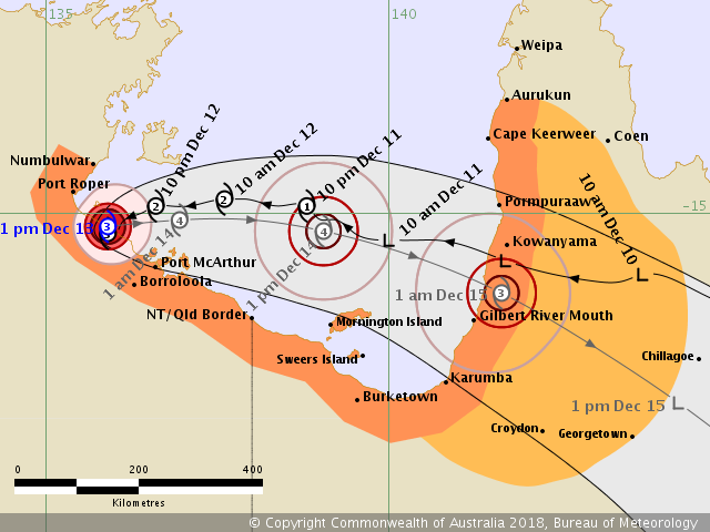
It is currently located on the coast in the southwestern Gulf of Carpentaria, between Port Roper and Port McArthur, just west of Bing Bong.
It’s position is near stationary, but it is forecast to start moving eastwards back towards the Queensland coast on Thursday before crossing along long the southeast Gulf of Carpentaria coast between Karumba and Pormpuraaw Friday.
Warning are in place for Numbulwar in the Northern Territory, to Aurukun in Queensland, including Borroloola, Mornington Island, Karumba, Kowanyama and Pormpuraaw.
While the a watch zone extends inland from Karumba to Aurukun as far as Georgetown, Chillagoe and Coen.
Sustained winds of around 150 kilometres per hour have been recorded at the eye of the cyclone, with wind gusts to 205 kilometres an hour.
Islands and coastal areas of the western and southern Gulf of Carpentaria are expected to receive heavy rainfall today, which may lead to flash flooding.
As the cyclone approaches the coast, a storm tide between Port Roper in the Northern Territory and Karumba in Queensland may develop.
The weather bureau expects the cyclone to weaken after making landfall, before making its way down Queensland’s east coast bringing heavy rain and flash flooding which could cause further damage in bushfire-affected areas.
Cyclone preparedness information is available HERE and more information on weather warnings is available HERE.
Links to information and emergency services: