Photo: Bureau of Meteorology
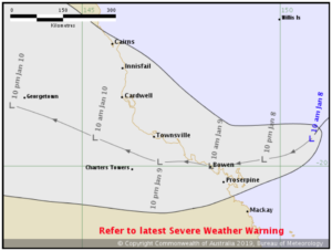
Ex-tropical cyclone Penny is forecast to bring heavy rain and potentially damaging winds as it crosses the Queensland coast between Mackay and Townsville overnight tonight or on Wednesday.
A severe weather warning is in place for coastal regions between Alva Beach and Sarina for damaging winds and heavy rainfall which may lead to flash flooding.
Heavy rain will initially develop around coastal regions today with isolated falls in excess of 200mm possible.
The Bureau has issued a new Flood Watch today for coastal catchments from St Lawrence to Cape Tribulation including the Mackay, Townsville and Cairns surrounding regions.
Damaging winds with wind peak gusts of around 90 kilometres an hour are expected to develop about exposed coastal and island locations in the warning area today, particularly about the Whitsunday Islands.
Queensland Fire and Emergency Services advises that people should:
- Move your car under cover or away from trees;
- Secure loose outdoor items;
- Seek shelter, preferably indoors and never under trees;
- Beware of fallen trees and powerlines;
- Never drive, walk or ride through flood waters. If it’s flooded, forget it;
- Keep clear of creeks and storm drains; and
- For emergency assistance contact the SES on 132 500.
For the latest information see Warnings and https://www.bom.gov.au/cyclone/.